Search
Close this search box.

Your Definitive Guide to LiDAR Technology

In a time when efficiency and accuracy are both advantages and necessities, LiDAR (Light Detection & Ranging) technology has established an essential role in shaping the future of how we perceive and interact with the world around us.

The latest market research indicates that the global LiDAR industry, with a valuation of $1.4 billion in 2023, is projected to expand to $3.7 billion by 2029. This swift expansion can be attributed to several key drivers, including ongoing innovation, a surge in demand for high-precision 3D mapping, and a broadening of its applications across various sectors such as smart cities, autonomous vehicles, and more.

As we stand on the brink of technological revolutions, where the boundaries of possibility continually expand, LiDAR technology emerges as a key player. Its ability to generate precise, three-dimensional information about the physical world opens up new horizons for innovation, efficiency, and safety in automotive and environmental management, urban planning, and beyond.

Serving as a comprehensive guide, this article delves into the intricacies of LiDAR technology, exploring its transformative capabilities and the myriad ways it promises to reshape our future.

Contents

What is LiDAR and How Does It Work?

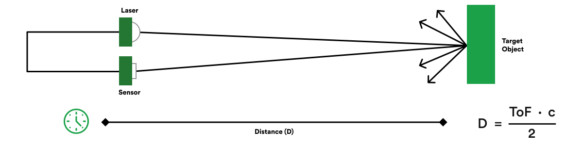
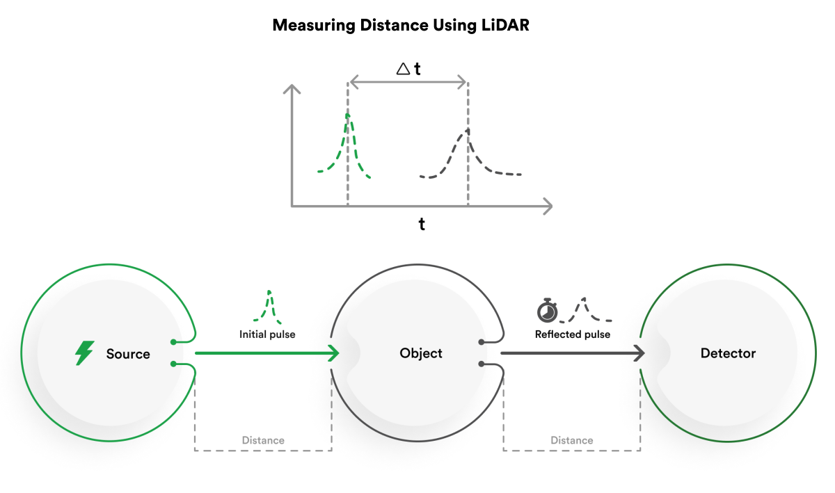
Imagine using light to see the world in 3D, not just flat images. That’s the power of LiDAR, a technology that works like radar but with laser light instead of radio waves. By bouncing light pulses off objects and measuring how long it takes to return, LiDAR creates incredibly detailed, high-resolution maps of its surroundings.

Think of it like this: a flashlight in a dark room. You can shine it around to see the shapes of objects, but you don’t know how far away they are. LiDAR is like a super-precise flashlight that measures not just the direction of the reflection, but also the exact time it takes for the light to bounce back. With this information, LiDAR can build a precise 3D model of everything it “sees,” even in complete darkness or low light conditions.

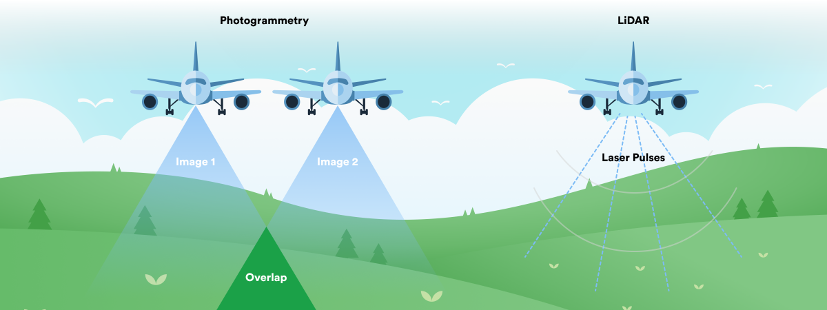
This makes LiDAR incredibly versatile. It’s used for everything from creating accurate maps of cities and forests to guiding self-driving cars and even exploring the surface of Mars! Unlike cameras that rely on visible light, LiDAR can see through fog, dust, and even thin layers of clouds, making it a powerful tool for all kinds of applications.

Here are some key points about LiDAR:

  • Similar to radar, but uses light instead of radio waves
  • Measures distance by timing reflected light pulses
  • Creates high-resolution 3D maps of its surroundings
  • Works in all light conditions, even darkness
  • Used in many applications, from mapping to self-driving cars


While LiDAR excels at measuring distances, its potential goes far beyond that. It’s a powerful tool for creating detailed 3D maps and images, making it invaluable in engineering and various practical applications.

Two Ways to Measure Time-of-Flight:

Imagine LiDAR like a super-precise flashlight that measures how long it takes light to bounce back from objects. There are two main approaches:

  • Single-shot direct time-of-flight (dToF): A laser pulse is sent, and the time for its reflection is measured. Distance is calculated using the speed of light. This method is fast and can detect multiple objects but works in both short and long ranges.
  • Indirect time-of-flight (iToF): A continuous light wave is emitted, and the phase shift between the sent and received waves determines the distance. This approach is better for shorter ranges and controlled lighting conditions.


iToF vs. dToF:

  • iToF: More common, better for short ranges and controlled lighting.
  • dToF: Faster, works in both short and long ranges, detects multiple objects.

how Lidar works 

The origins of LiDAR trace back to the early 1960s, shortly after the invention of the laser, with its initial applications in meteorology and aerospace. In the 1970s NASA used this laser-based remote sensing technology to develop exploratory spacecraft. Applications for LIDAR continued to expand into measuring the properties of ocean water and the atmosphere for topographic mapping purposes. Ice sheets and the canopies of forests were also explored with LIDAR technology.  

Over the decades, advancements in computing power and sensor technology have dramatically expanded LiDAR’s applications, transforming it from a specialized scientific instrument to a critical tool in numerous fields. Its development timeline showcases a remarkable innovation journey, underscored by a growing recognition of its ability to provide precise, real-time data for complex analysis and decision-making. 

LiDAR, cameras, and radar represent three distinct sensing technologies with unique operational principles, strengths, and limitations tailored to specific applications. LiDAR employs laser beams to measure distances, creating detailed three-dimensional maps, making it exceptionally suitable for environments requiring precise depth information and object detection.  

The versatility of LiDAR technology is evident in its various forms, each tailored to specific applications and environments. 

  • Airborne LiDAR: Deployed from aircraft, this type is subdivided into topographic Lidar, which maps land surfaces, and bathymetric Lidar, which is specialized for underwater surfaces by penetrating water with green light. 
  • Terrestrial LiDAR: Ground-based systems that provide detailed images of structures and landscapes, crucial for surveying and 3D modeling in construction and archaeology. 
  • Solid-State LiDAR: This represents a leap towards more robust, compact, and reliable systems, eliminating moving parts for better durability and cost-efficiency, which is pivotal for automotive applications. 
  • 2D vs. 3D LiDAR: 2D LiDAR scans a single plane, ideal for applications like obstacle detection in warehouse robots, while 3D LiDAR captures comprehensive volumetric data, essential for complex modeling and autonomous vehicle navigation. 


Unlike LiDAR, cameras capture images using visible light to produce two-dimensional representations, excelling in capturing color, texture, and visual details but relying on complex algorithms for less accurate depth inference.  

On the other hand, radar uses radio waves for object detection and distance measurement, offering reliable performance in adverse weather by penetrating fog, rain, and snow, thanks to its longer wavelengths, though at the expense of the high resolution and precision that LiDAR provides.  

Together, these technologies complement each other, with LiDAR offering high-resolution 3D mapping, cameras providing rich visual information, and radar ensuring robust detection in challenging weather, highlighting the importance of selecting the right technology based on application-specific needs. 

How to measure distance with LIDAR

LiDAR vs Photogrammetry

LiDAR and photogrammetry are two powerful technologies used to capture the world in 3D, but they differ in their approach and strengths.

LiDAR employs laser pulses to measure distances, creating a highly detailed point cloud representation of an area. Think of it like millions of tiny dots building a 3D picture. This method excels in situations with low light or dense vegetation, like underwater environments or mapping under forest canopies, where traditional cameras struggle.

Photogrammetry, in contrast, relies on multiple overlapping images captured from different angles. Like piecing together a puzzle, software merges these images to create a textured 3D model. This approach excels in capturing rich visual details like colors and textures, but requires good visibility and struggles in darkness or with obscured features.

Ultimately, the choice between the two depends on the specific needs of the project. LiDAR reigns supreme for precise measurements and challenging environments, while photogrammetry offers visual richness and cost-effectiveness. Often, combining both technologies paints the most complete picture, showcasing the diverse tools we have for mapping the world in 3D.

LiDAR - Key Features and Benefits

With its accuracy and adaptability, LiDAR technology leads innovation in various fields. Its unique qualities go beyond simple measurement, providing benefits that significantly improve data accuracy, operational effectiveness, and environmental awareness. 

High-Resolution 3D Mapping Capabilities 

One of the most notable features of LiDAR is its ability to produce high-resolution, three-dimensional maps of physical environments. Unlike traditional two-dimensional imaging, LiDAR’s 3D mapping capability captures the complexities of landscapes, structures, and objects with remarkable detail and accuracy. This is particularly beneficial in applications such as urban planning, where detailed topographic data inform infrastructure development, and archaeology, where it enables preserving historical sites without physical intrusion. The depth of data provided by LiDAR facilitates complex analyses and simulations, empowering professionals to make informed decisions based on comprehensive environmental models. 

Accurate Distance Measurements and Object Detection 

LiDAR excels in providing precise distance measurements, a feature integral to its utility in autonomous vehicle navigation, robotics, and construction. LiDAR systems can accurately calculate distances by emitting thousands of laser pulses per second and measuring the time each pulse takes to return. This capability supports the object detection and avoidance systems crucial for the safety and reliability of autonomous vehicles, enabling them to navigate complex environments safely. Similarly, in construction, these measurements assist in the accurate planning and execution of projects, ensuring structures are built to exact specifications. 

All-Weather and Low-Light Operation 

The operational resilience of LiDAR technology supports its effectiveness across various applications. Unlike optical cameras, Lidar systems do not rely on ambient light, allowing them to operate effectively in low-light conditions or complete darkness. This feature is invaluable for 24/7 surveillance applications, wildlife monitoring in nocturnal settings, and ensuring autonomous vehicles can navigate safely regardless of the time of day. Moreover, while LiDAR’s performance can be affected by extreme weather conditions, advancements in technology have improved its reliability in fog, rain, and other challenging environments, expanding its applicability across industries and tasks. 

Ability to Penetrate Certain Materials and Vegetation 

LiDAR’s capability to penetrate light-obscuring materials like vegetation offers unique advantages in fields such as forestry, agriculture, and land management. By filtering out reflections from foliage and capturing the ground level, LiDAR enables the creation of detailed terrain models, even in densely vegetated areas. This allows accurate soil erosion studies, forest management practices, and agricultural planning, contributing to more sustainable management of natural resources. Similarly, LiDAR can penetrate window surfaces to model buildings’ interiors in urban and architectural applications, aiding in the design and renovation processes. 

Real-Time Data Acquisition and Processing 

The real-time processing capabilities of LiDAR technology mark a significant advancement in data acquisition speed and usability. Systems equipped with LiDAR sensors can interpret and react to their surroundings instantaneously, a critical requirement for applications demanding immediate responses, such as autonomous driving, emergency response, and dynamic environmental monitoring. This quick data processing enables devices and systems to operate autonomously, adapt to changing conditions, and make decisions based on the latest ecological inputs, showcasing LiDAR’s role in supporting smart, responsive technologies. 

LiDAR system components

LiDAR - Key Features and Benefits

LiDAR technology, with its unparalleled precision and versatility, has rapidly become the backbone of innovation across various industries. From revolutionizing supply chain logistics to pioneering advancements in construction, automotive safety, and beyond, LiDAR’s applications are as diverse as they are transformative. 

Supply Chain and Logistics 

LiDAR technology is pivotal in automating and optimizing supply chain and logistics warehouse operations. Advanced LiDAR systems are instrumental in inventory management, enabling precise tracking of goods through 3D mapping of warehouse spaces. This capability improves inventory accuracy and facilitates more efficient use of storage space. Automated Guided Vehicles, equipped with LiDAR sensors, navigate warehouses with remarkable precision, safely transport goods, and reduce manual labor requirements. Furthermore, LiDAR aids in package sorting processes by rapidly scanning parcels, determining their dimensions, and optimizing packaging and loading strategies.  

In route planning and traffic management, LiDAR-equipped drones and vehicles gather detailed data on road conditions and congestion, enhancing delivery efficiency and reducing transit times. These applications collectively contribute to greater supply chain visibility and traceability, ensuring that products move seamlessly from origin to destination. 

Construction 

The construction industry benefits significantly from LiDAR’s high-resolution 3D modeling and scanning capabilities. By capturing detailed images of buildings and infrastructure, LiDAR enables the creation of accurate digital twins, enabling architects and engineers to plan and simulate projects with higher precision. Site surveying and volumetric measurements become more efficient, reducing the time and cost associated with traditional methods. LiDAR technology is used during construction for progress monitoring, ensuring that projects adhere to their timelines and specifications. This real-time data acquisition allows for immediate adjustments, improving project outcomes.  

Additionally, LiDAR supports as-built verification, ensuring structures are built as designed and seamlessly integrated with building information modeling systems for comprehensive project management. Moreover, its ability to identify potential safety risks and monitor worker movements helps mitigate accidents on construction sites, safeguarding personnel. 

Automotive 

LiDAR’s impact on the automotive industry is profound, particularly in developing self-driving cars and Advanced Driver-Assistance Systems (ADAS). By providing high-resolution, three-dimensional images of the vehicle’s surroundings, LiDAR enables autonomous vehicles to detect and navigate obstacles, anticipate environmental changes, and make informed real-time decisions. This enhances lane departure warning systems, collision avoidance capabilities, and pedestrian detection, significantly improving road safety. Furthermore, LiDAR contributes to developing precise 3D maps for navigation and localization, which is essential for the accurate operation of autonomous vehicles. 

Other Industries 

Beyond these sectors, LiDAR’s applications extend into agriculture and forestry, where it supports land management, crop yield estimation, and precision farming, enabling more sustainable and productive practices. In archaeology and cultural heritage, LiDAR technology provides a non-invasive means to preserve and document ancient sites, offering insights into historical landscapes without disturbing them. Robotics and drones leverage LiDAR for mapping environments, avoiding obstacles, and navigating autonomously, enhancing their functionality and expanding their use cases. Environmental monitoring benefits from LiDAR’s terrain analysis capabilities, which play a crucial role in flood mapping, forest fire detection, and biodiversity conservation efforts, contributing to our understanding and protection of natural habitats. 

Are you looking to harness the power of LiDAR technology for your next-gen projects?

Future Trends and Developments in LiDAR Technology

The evolution of LiDAR technology is marked by rapid advancements and expanding applications, promising a future where its integration will be even more significant across various sectors. As we peer into the horizon of LiDAR’s future, several key areas emerge as focal points for growth, innovation, and transformation. 

Advancements in Miniaturization and Cost Reduction 

One of the most significant trends in the evolution of LiDAR technology is the drive toward miniaturization and cost reduction. Early LiDAR systems were bulky and prohibitively expensive for widespread use, but recent innovations have led to the development of smaller, more affordable LiDAR sensors. This trend is particularly crucial for consumer-level applications, such as smartphones and personal drones, where size and cost are critical considerations. Additionally, the automotive industry benefits immensely from this trend, as the integration of affordable LiDAR sensors can significantly enhance the safety features of vehicles, making advanced driver-assistance systems (ADAS) and autonomous driving capabilities accessible to a wider market. 

Integration with Other Sensor Technologies and AI 

The fusion of LiDAR with other sensor technologies and artificial intelligence represents a frontier for creating more refined autonomous systems. By combining LiDAR’s precise distance measurement capabilities with the rich visual information from cameras and wide-ranging radar detection, systems can fully understand their environment. AI algorithms are crucial in processing and interpreting this multisensory data, enabling real-time decision-making and predictive analytics. This integrated approach enhances applications in autonomous vehicles, smart cities, and robotics, where complex environmental interactions require subtle perception and rapid response. 

Development of Solid-State LiDAR Systems 

The advent of Solid-State LiDAR systems marks a leap forward in durability, reliability, and performance. Unlike traditional mechanical LiDAR systems, which rely on moving parts to scan the environment, Solid-State LiDAR uses no moving components, reducing wear and tear and extending the device’s lifespan. This innovation also allows for more compact designs, opening new possibilities for integrating LiDAR into a wider range of products and applications. Solid-State Lidar is expected to become a game-changer in the automotive industry, enabling more robust and reliable autonomous driving systems that can withstand the rigors of everyday use. 

Applications in Healthcare, Retail, and Security 

As LiDAR technology evolves, its applications expand into new and unexpected fields. In healthcare, LiDAR sensors can facilitate patient monitoring systems that detect falls or monitor breathing, offering a non-invasive way to provide continuous care. In the retail sector, LiDAR can enhance customer experiences through interactive displays and efficient store navigation systems, improving service and operational efficiency. Furthermore, LiDAR’s ability to precisely map environments and detect movements makes it a valuable tool for security applications, from monitoring public spaces to protecting sensitive locations. 

Sustainable Development and Environmental Monitoring 

LiDAR’s role in promoting sustainable development and enhancing environmental monitoring efforts is increasingly recognized. Its high-resolution mapping capabilities are invaluable for tracking ecosystem changes, assessing disaster impacts, and planning conservation efforts. LiDAR data can inform climate change models, forest management practices, and urban planning strategies, contributing to more informed and sustainable decision-making processes. 

Wrapping Up

The widespread adoption of LiDAR technology can impact business operations and society functions significantly. By enabling more efficient and safer autonomous transportation solutions, improving the accuracy of environmental monitoring, and enhancing the precision of infrastructure development, LiDAR technology creates smarter, more sustainable cities and ecosystems. Its role in driving innovation extends beyond economic benefits, offering solutions to some of our time’s most pressing environmental and social challenges. 

As we look towards the future, integrating LiDAR technology into our daily lives and industries becomes increasingly crucial. Businesses, policymakers, and innovators are called upon to recognize the value of LiDAR solutions and invest in their development and deployment. Collaboration between technology providers, researchers, and industry stakeholders is crucial to unlocking the full potential of LiDAR, ensuring it can contribute to advancements that benefit humankind and our planet. 

The journey towards harnessing the full capabilities of LiDAR technology needs partnerships with experienced R&D and technology providers.  

rinf.tech, with its vast expertise in developing and implementing cutting-edge technological solutions, is an invaluable ally in exploring the possibilities of LiDAR technology. By leveraging such partnerships, industries can accelerate their adoption of LiDAR, driving innovation and securing a competitive edge in the rapidly evolving technological landscape. 

Related Articles

Looking for a technology partner?

Let’s talk.